2007 – Rockhopping in the Channel
An auspicious start
The weather in the 8 weeks preceding our holiday had been universally horrible, with ( apparently) La Nina sending the Atlantic jet stream South and giving us floods and a Scottish climate instead of a summer. Thinking we were in for more of the same, we stocked the boat with a veritable library of books in case we had to hole up for extended periods. To our delight however, as we thrashed out of the Solent into 25 knots of SW wind, the Met office was predicting that the next front would presage, of all things, a Northerly!
The rain poured down on our anchorage in Studland , and we set our alarm for 0430 which was when we believed the front would clear. And it did , right on time, Quick as a flash we were under way with the kite up , surfing past Peveril point and heading South in 25 knots ( more than we had bargained for – it was 10 when we hoisted !) . There was a big SW swell and a rapidly building N sea – which made for pretty boisterous conditions – but progress was good.
Gradually the wind eased , and the boat was tossed around in the cross seas with the inevitable result that just on the edge of the shipping lanes we got the mother of all spinnaker wraps – not just one – but 6 times round the forestay and stuck fast.
It was too rough to go up in a chair , so once the air had turned less blue , we put the engine on to avoid the 6 ships that had inevitably appeared to be coming to see our embarrassment . Lo and behold , with the wind nearly dead astern the wraps started to come out one by one , propelled by just the right kind of friendly back eddy from the mainsail. We had had visions of having to divert to Alderney to untangle it all in public view , so this was a very welcome miracle . With two wraps left we leapt into action – clawed the kite to the deck and rehoisted with a small jib up to avoid a re-run.
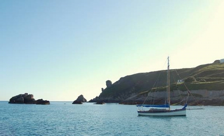
The skies now cleared and we spent the rest of the day alternatively motoring and sailing as the wind came up and down , so that we could take our tide through the Alderney race and down to Jersey . The last 2 hours provided us with a fine NW sea breeze to propel us to St Catherines Bay , dropping the kite outside the mole and swinging in to anchor, eat and fall into bed after a splendid start to the cruise.
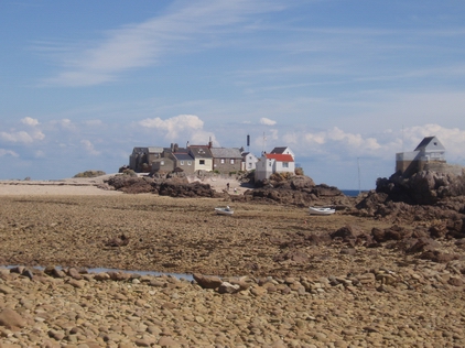
Rocks ahead!
 It was another early start next morning as I wanted to get to Les Ecrehou before the crowds . Sure enough despite a very slow and cautious approach we were the first to arrive at this extraordinary little group of houses marooned in the middle of the sea ( it was the top of the tide). It was coming up to Springs and the only place deep enough at low water , but out of the stream , had moorings laid , so we picked one up. I don’t feel bad about this. If people must fill the best places with their tackle then they must expect it to be used , and indeed the subsequent hordes that poured out of Carteret soon picked up the rest , so I guess that it is generally the accepted thing to do.
Here we had a wonderful 36 hours, living to the rhythm of the tide. As the water fell away revealing miles of sand and rock , so boats appeared from near and far , some to join us in the anchorage – but most to dry out on legs in the sandy lagoons that appeared as if by magic before our very eyes.
As the tide rose , the process was reversed . The sand and the rocks disappeared , the boats left one by one , and by dusk we were on our own again with just the houses for company – surrounded once more by water. Each day we explored in the kayak, discovering ways out of the archipelago on the receding water before running back down the sound with the flood tide to regain our ship. Kayaking to the North of the rocks I saw two dolphin breaching – and had to make Lynda practice not jumping if they came close. Sadly they didn’t, although I believe Lynda was secretly relieved.
Finally , at dead low water on our second day we slipped our mooring and headed South once more , anticipating a gentle spinnaker run down to Chaussey in the evening sea breeze.
Understanding Chaussey
In fact the cumulus disappeared , the sea breeze died , and just as we were resigned to finishing the passage under engine – a NE wind sprang up and gradually built so that by the time we were approaching the Islands , we had 22 knots of breeze and were sluicing along at 9 knots.
At HW Springs , the outer approaches of the North Channel into Chaussey appear be open water , so once the spi was out of the way I didn’t feel it necessary to drop the main . In good visibility the leading marks are superb – but the further in you get , the narrower the channel , and the less room you have to round up. As a result we charged through the moorings at 7 knots , dropped the main in the South entrance – and under rather more control proceeded to try and work out where to moor. It would have been more seamanlike to have slabbed a couple of reefs – or just come in under a small jib – but in fact it went well enough , as the Channel was very familiar from our last visit.
But where should we anchor? We had arrived at a difficult time as night was falling , all the rocks were covered , and a strong weather going tide meant that some of the boats that had anchored were sailing their hooks out . On the other hand the moorings looked horrendous with up to 8 boats abreast. Eventually we came alongside a British motorboat who had picked up ( unbeknown to all of us) a fishing boat mooring and so had less of a crowd attached. Apart from a French boat who came alongside in the night having bent a stanchion in the bunfight at the mooring trots , we spent a peaceful enough night , but resolved to search out a place to anchor the following day.
Port Marie is a little Bay to the West of the Sound , and with the wind still in the NE , we slipped out and anchored there in the morning , spending the day exploring the main Island on foot and identifying the best place to anchor in the Sound in the forecast NW wind . Sure enough , when the wind did change , Port Marie became fairly uncomfortable and at first light were ready to move – but as our anchor was underneath a French boat – we had to wait for them to wake up.
Once moved however we were ready to explore , and slipped off into the eastern rocks in the kayak , searching for the main passages through the Eastern rocks and isles.. A short portage was required when the ebb tide left us stranded for a while – but we were soon away paddling though what initially seemed a deserted rockscape , except at each turn we found a French boat at 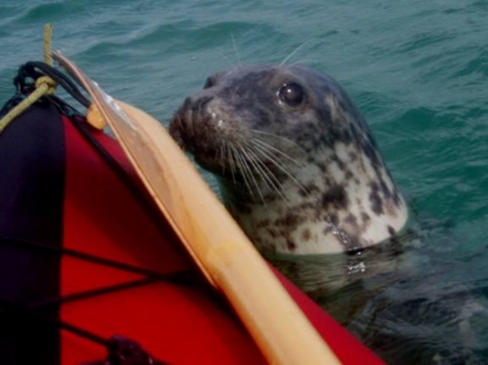 anchor , or dried out , their crews hunting for lunch on the rock pools and shallows . The North of the archipelago was open to the fresh NW wind , but the kayak handled it well and eventually we rejoined the Northern end of Chaussey sound and turned gratefully downwind. We had made such good time that we were too early to cross the watershed so we slowed down and looked around. To our delight , up popped a seal who proceeded to entertain us by trying to swallow a large flat fish , and having finished that , came up to see if we would provide a desert! Eventually he tired of our company , but this still left a 2 hour wait for the tide – so we carried the kayak over the saddle and drifted back down to the boat.
So , for future reference , anchor overnight at the southern end of the sound – or in Port Marie in a NE wind , and spend daylight low tides exploring round the archipelago. Unless you have the place to yourself, avoid the mooring trots!
The Minquiers
That night I had to come clean to Lynda . Ever since reading ( and watching) “The Wreck of the Mary Deare” as a child I had fancied exploring the Minquiers . The gentle NW wind forecast for the next day was ideal; we would never have a better opportunity. But it was not to be a comfortable day. GPS and a chart plotter undoubtedly made it easier – but feeling our way in through temporarily hidden rocks , searching for a deep enough spot to anchor with a tidal range of 11 metres , watching rocks emerge through the water uncomfortably close , and finally making our way out again near low water ; all this was pretty tense stuff.
 The houses on Maitresse Isle had an abandoned air ( even though one was currently being worked on ) and the two boats that arrived at the same time as us left once the tide began to drop , which contributed to the general air of menace that hung about the place. Just outside the anchorage however , a single little French motor boat nosed busily in and out of the nooks and crannies , hunting voraciously all day long. They at least didn’t seem overawed by the place , although to be fair they drew a lot less and could take the ground if necessary.
The kayak was launched once more and we took a gentle tour at low water before going ashore to pay homage to the most southern building in the British isles ( a loo that doubles as a leading mark!). The view to the West over mile upon mile of rocky reefs did nothing to relax us and it was not until we were a full five miles south and clear of the last rock that we could breathe easily again, spinnakering slowly to St Malo to top on supplies
Brehat
A day ashore at St Malo was nice – but enough , so we were soon on our way again to Brehat , beating into 12-15 knots of warm wind, and as it was now 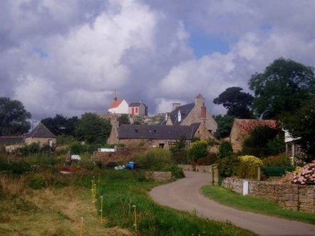 getting neapier , anchoring in the Kerpont in the lee of a large rock. Our first full day was spent exploring the East coast by kayak , with a trip into Le Bourg the next day via La Corderie – the drying harbour on the West coast.
This really is the most pleasant of places – lovely anchorages – peaceful vehicle free walks and the nicest of little village squares where you can reprovision , take a leisurely coffee in the sun and for the second time in 15 years – come away with a painting from the artists exhibiting out in the open. Getting it all back to the boat in the kayak was perhaps another matter – but we managed it.
..And Home
A forecast of fresh northerlies in 2 days time prompted to us to take a sparkling NW wind to Guernsey . Navigation was by a folio of 17th century charts bought at a bookstall in St Malo, and like their modern equivalent – the course took us past Les Roches Douvres. Should we explore these as well? No , they were a rock too far ! The tide was dropping like a stone and the weather did not feel settled enough – so we contented ourselves with a close pass , some long distance photos and a secret sigh of relief that we could stick to deep water navigation. Our ancient charts all showed anchorages on the south side of Guernsey – so we slipped into Petit Port at dusk , completely protected from the force 6 Northerly forecast for that night.
The same charts showed a big bay on the South coast of Alderney , with no corresponding indent on modern charts. I decided that it must refer to Longey Bay – especially as this it seemed to be protected by a castle, a common finding in old sailing ship anchorages . The inaccuracy might be explained by the fact that the SW coast of Alderney is “difficult “ and unlikely to have been surveyed by unwieldy !7th century sailing ships. The trip there ( via a short lunch stop off Sark ) was a brisk beat , tacking in to the bay and anchoring under sail. By and large it was protected , except perhaps for the start of the flood which produced a NE counter current off the mouth of the bay and a popple which rolled us about for a while.
 For our final day I had promised myself an exploration of Alderney and Burhou before an expected light wind crossing home. With large scale chart in hand and the chart plotter as back up we inched our way around the Island inside most of the rocks – and crabbed across the Swinge to Burhou to await the East going tide. Miraculously a gentle Northerly sprang up at just the right time so we could just about make our course at 5 knots. As the afternoon progressed , so the wind backed and strengthened so that far from crossing slowly , we ended up thrashing across at 8 knots and were tied up and asleep by 2 am.
What a nice cruise. Against all the odds , the winds had been kind and weather had been wonderful . Now it was time for the Fastnet, but that was to turn out to be a rather different story.